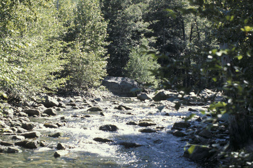
Haypress Creek is a prolific stream with beautiful scenery and equally lovely fishing. It begins in the high country as a trickle through a meadow. Then it meanders through the slow pools of a second meadow into a shallow, brushy canyon. After a couple of miles, it increases in gradient and becomes a rocky plunge-pool stream for the last third of its journey to the North Yuba, slowing down only in the flood-ravaged pools by Wild Plum Campground.
In the meadows at the top, brook trout are the residents and they rarely get as large as 10 inches. Any tiny dry fly will catch them, since they mostly subsist on midges. As you go down into the canyon, the small, deep pools will contain a few brookies, but the long, shallow ones are a better bet for fish. You can have a fifty fish day here, all on dry flys. Roughly half a mile below Long Valley Creek there is a six-foot falls, below which the brookies will be fewer and skinnier. Now the center of every pool will hold plump, silvery rainbows, which sometimes reach 12 inches. You can use a slightly larger dry fly here, since the insect life includes the more sizable mayflies, caddisflies, and stoneflies found in a typical freestone stream. If you access Haypress Creek from the lower end, it falls steeply through a mass of gray boulders flung down by spring floods, with little good holding water, and the fish population is lower as a result. Near the campground at the bottom, you will catch the occasional planted rainbow. Haypress Creek’s two main tributaries are Long Valley Creek, which is tiny and almost unfishable because of thick brush, but which does hold some brookies, and Milton Creek, which is a pleasant fishery, dealt with below.
You can reach Haypress Creek from several directions. The meadow at the top can be reached by taking Henness Pass Road off Highway 89 north from Truckee. Take the first turnoff signposted to Forest Road 88 (the Bald Ridge Loop) on the right after Webber Lake, not the second turnoff so posted. This is a good dirt road that goes over the hill and drops down toward the top meadow. In about 2 miles, stay right where Forest Road 88 heads left and you’ll cross Haypress Creek on a railroad trestle bridge. After the bridge, keep left, and you’ll come to the second meadow in 1.5 miles. Park at the earth barrier in 0.5 miles, then hike the closedoff jeep road downstream. If you stay left back at that first junction on the Bald Ridge Loop, you can access the middle stretch of the creek after 4.0 miles by parking in a pullout and hiking down the hill a short way.
You should be just below a tiny tributary that enters from the south, the direction from which you approach. Notice that for some distance before this, a steep ridge rises between the road and the creek and prevents access.
You must carry a topo map to accomplish this short cross-country hike. If you keep going for another 0.6 miles, you’ll come to a gravel road that goes 1.0 miles down to a new hydropower dam. (I recommend walking this, since fallen trees often block the road.) Turn right, down into the canyon, in about 0.7 miles.
To reach the bottom end of Haypress Creek from Highway 49, turn right on Wild Plum Road, just east of Sierra City at the 29.9 mile marker. Then follow the signs to Wild Plum Campground, crossing the bridge over the North Yuba. Park in the trailhead parking area on the right before the campground, from which a steeply climbing trail goes upstream. If you want to access the upper reaches from Highway 49, drive up to Yuba Pass, then turn right on Forest Road 12, following it for 10.8 miles to a turning on the right, signposted “Haypress Valley 3 miles.” (This is Forest Road 12-69.) In about a mile, turn left into the top meadow or continue straight on to the second meadow and the north-side trail.